Showing posts with label Quebec. Show all posts

Sunday, September 27, 2009

St. Marc Sur Richelieu to St. Paul D'Iles aux Noix


Wow, today's the day. Last day in the Canadian heritage canal and lock system--we'll exit the final lock later today and then have a short run down the River Richelieu to the USA. Left the dock at St. Marc Sur Richelieu at 8:44am with cloudy but dry weather; around 50 degrees F. We average 6.4 knots, 2,200 rpm.


We arrived at Fort Chambly around 11:30am. After tying up at the blueline wall on the north side of the lock, we checked in with the lock operator. With the reduced fall season operating hours we had only about 40 minutes before we would have to enter the lock so our passage thru the complete Chambly lock system could be completed today. Normally this would be a good thing, however, we wanted to stop and tour the fort but we didn't have enough time. Schucks.


The Chambly Canal, which has been used for navigation since 1843, played a primary role in the forestry products industry in Quebec, and in the export of lumber to the US. Building for the canal began in 1831; work was halted several times; due to funding problems, the rebellion of the Patriots, and a cholera epidemic. Twenty kms in length, the canal consists of nine locks, eight of which are operated manually, and several swing, slide and lift bridges. The stair locks are the only ones of their kind in Quebec.


Saturday, September 26, 2009

Montreal to St. Marc Sur Richelieu


Pecan left Montreal this morning at 9:08am with cool 48 deg F conditions and fog dissipating. We scooted up the St. Lawrence about 40 miles Sorel where we entered the Richelieu river (which'll take us south back to the USA via the Chambly canal and Lake Champlain.)


We have a good 5 to 6 knot current going with us for much of the lower part of our journey on the St. Lawrence River. the Jacques Cartier bridge dead ahead.


Looking back at the Montreal skyline.


A bit dark in the photo, but you can see we are running OpenCPN navigation software with a Canadian Hydrographic Service raster chart showing our position on the St. Lawrence River.

Freighter traffice passing port to port on the river. The PANAGIA was the only large ship we meet the whole day.


Entrance to the Richelieu river is quite non-descript. If you're not looking it'd be easy to pass by the river; what with industrial plants and wharves lining the shore.


Marina/resort along the Richelieu where we tied up for the night.

Friday, September 25, 2009

Montreal


A rarity for us on this trip, we stopped for a whole day to tour around Montreal. After touring a museum in the old town section, we took the subway to the Mont Royale stop and hiked from there thru the park to the top of the mountain. Loads of trails up the mountain--many suitable for mountain and hybrid bikes. Great views from the top, as can be seen from the little video below. After that, we hiked straight down and wound up at McGill University. McGill reminds us of Mike's school at the University of Pennsylvannia in that you have a sizeable university in a city/urban environment. Still walking, we made our way to Chinatown and found a delightful small restaurant. Crowded, and no single tables available, we were offered to sit a large circular table with 3 other couples if we want to be seated now. We did and had nice conversations with our dinner 'partners'.


Port D'Escale marina has a overnight promotion for weekday nights. CAD$1.65/foot/day (up to 65 ft.). I think we lucked out arriving on Thursday since it looks we were charged for two nights at the promo rate. Includes 30 amp power and water and use of laundry. They issue an electronic card key with a CAD$20 deposit so you can come and go thru the main entrance at will.


A bit of laundry in the a.m.


View of downtown from Mont Royale...it's really that close.


Arriving back at the marina at sunset.


Video from the top of Mont Royale.


Video panorama of Port D'Escale marina.

Thursday, September 24, 2009

Lachine to Montreal


Clear this morning, about 50 degrees F. Calm winds. Ran the diesel generator about one hour this morning for hot water, a little force-air heating, and battery charging. Left the dock to start the canal at 9am. In the map above, we entered the canal from the west at the lower end of the solid red line.


One of the key reasons we wanted to 'do' the Lachine canal and waterway system is because of the historical significance this canal made not only for Montreal but for Canada. The canal 'bridged' the Lachine rapids which were a severe and dangerous impedement to the exploration and settling of Canada. Opened in 1825, and widened twice in the 1800s, this is the first set of canals leading to the Great Lakes that preceded the St. Lawrence Seaway. Today, the restored canal cuts right thru the center of Montreal, is 12 kilometers long and there are five locks and 23 bridges.


These two photos I took last night where we tied up at the Lachine floating blue line docks. Rain had ended.


Tamara talking with our lock operator. We noticed--since on the Ottawa River--all the operator have a portable wireless device where they punch in our boat name, registration number and lock permit info. I guess we're being tracked!


Converted factories and warehouses are now urban condos and apartments along the canal.


Our first 8 foot bridge up ahead. We slow to about 1 mph--just in case we touch and have to stop. Of course, I trust Canada Parks folks but was perplexed with a diagram they handed out. This diagram, shown below, notes the bridges at 8 feet 0 inches. Well, if we could enter the canal with the maximum air draft of 8 feet 0 inches, wouldn't we then scrap the underside of all these 8 foot bridges? There's clearly some 'fudge factor' in the actual clearance for these low bridges--but they aren't telling us what that is. They did acknowledge this fudge factor: they said two boats passing each other under the bridges could create a bit of pitching. Therefore these bridges are a bit higher than 8 feet 0 inches but it'll remain a mystery.


Lachine bridge and lock diagram


I believe we cleared the bridge underside by 1 to 2 inches.


Stopped at Atwater Market for a bit of grocery shopping. Better know your French.


Official website for the vendors, merchants and growers at "Marche Atwater" here:
http://www.marche-atwater.com/


Final lock on the Lachine; here the lock operator--again--punches our info into his trusty handheld computer.


Exiting the Lachine at around 2:30 or so, we pass by the Habitat 67 housing development that were built for the Montreal expo back in, of course, 1967.


Arriving at the modern Port D'Escale marina in the old town section of Montreal along the St. Lawrence River. As you can see, the season is virtually over...less than a dozen boats here.


We walked around the old town of Montreal on this fine and clear day in September.


Intriguing bikes and bike rental kiosks all over the city. About CAD$5 a usage. The idea is that you ride to another location in the city and drop off the bike in the nearest kiosk there. I think they give you 30 minutes. And if you want to use it longer, you can, but it'll cost you.


Now getting dark in one of the narrow streets in old town.

Wednesday, September 23, 2009

Hawkesbury to Lachine


Pecan left Hawkesbury at 7:54am with cloudy and warm, 20 deg C, conditions. Winds 5 knots out of the SW. Water temperature 63 deg F. We timed our lea6ving to get to the Carillon locksite at their opening time of 9:30am. We arrived at 9:23am. This lock is notable because it is a whooping 65 foot water level drop and they employ a unique guillotine-style lock door on the downstream end. Check out the video of the door opening.
Next lock on the Ottawa was the St. Anne de Bellevue lock. By now it was raining but we had an uneventful lockthru. After this lock we entered the Lac Saint Louis and the St. Lawrence river.
We headed over the a small western hamlet of Montreal called Lachine so we could position ourselves for a transit of the Lachine canal. This canal was instrumental for Montreal to develop as a center of commerce during the earliest days because the rapids in the St. Lawrence (aptly named Lachine Rapids) were very dangerous and impeded navigation upstream towards the Great Lakes. At any rate, our navigating the Lachine canal required that Pecan to no higher than 8 feet 0 inches off the water. A Lachine canal/lock operator came down to the boat with a specially calibrated pole to measure Pecan. We cleared by just a couple of inches! Thank goodness we had fuel and water tanks 90% full.


We're a bit early--arriving at 9:23am and they start the first lock thru at 9:30am. Here we're tied to the western blue line wall awaiting instructions.


A view of the lock doors from the blue line wall.


On busy days during the season, Canada Parks Service has this nifty diagram showing the order or arrangement they want boaters to tie up to establish lock-thru priority. Today--virtually the end of the season--we are the only ones going thru.


This lock serves an additional major advantage--it's an integral part of Hydro-Quebec's Carillon generating plant, producing 752 megawatts of electricity.


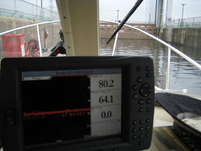
Depthsounder showing depth of 80.2 feet before we begin the descent.


One very nice feature of this lock--unlike all before--is the floating dock we tie up to *inside* the lock. No fussing with lines this time, and I can walk around as we descend.


From the Parks Canada brochure: "The Carillon Canal, inaugurated in 1834, provided a route around the rapids on the Ottawa River. Originally consructed for military reasons, the canal served commercial transport from the beginning. Completed in 1833, the first Carillon Canal would, with the Chute-a-Blondeau and the Grenville Canals, make it possible to clear a series of rapids covering 20 kms, called Long Sault. Adjacent to the hydroelectric dam, the impressive lock is more than 20 m high and today, boats can navigate the sharp drop in only 30 minutes. The same trip in the original canal system involved three canals and eleven locks.


Depthsounder showing we descended 58.7 feet.


Our descent complete, here's a video of the Carillion 'guillotine' lock dock opening upwards.


Goodbye Carillon lock.


As the drizzly rain sets in, we've entered the last set of locks in the Ottawa River--Sainte-Anne-de-Bellevue lock. Tamara is out on the floating dock talking with our Parks Canada lock operator.
From the Parks Canada brochure: The Sainte-Anne-de-Bellevue Canal is located at the mouth of the Ottawa River. It links Lac Saint-Louis and Lac des Deux-Montagnes. It is located on a well-known waterway in Quebec and is the busiest historic canal in the province. The canal was used for commercial shipping from the time of its inauguration in 1843, and it quickly became part of the Montreal-Ottawa-Kingston navigation triangle. The Sainte-Anne-de-Bellevue Canal played an important role in the inland movement of immigrants and of lumber shipping. Today, the Sainte-Anne-de-Bellevue lock is used primarily by pleasure craft. With many terraces near the site, it has a unique urban feel.


By mid-afternoon we've reached the Lachine canal entrance. After tying up at the blue line floating dock, we walked to the Lachine canal authority office (and museum) to request/schedule our lock-thru for the following day. Also, we had to get Pecan's height off the water, or air draft, measured to make sure we would clear their lowest fixed bridges--8 feet! Here's the lock operator measuring Pecan with their customized pole. As you can see, we just make it.


About a week or so ago, when we were looking at deciding how to proceed towards Montreal, I heard and read about the 8 foot maximum air draft necessary to do the Lachine canal. (Vessels with higher air drafts must proceed thru the big ship locks in the St. Lawrence river.) But, I wondered, how hard and fast was this "8 foot". Was that plus or minus six inches? 1 foot? Well, we soon found out and I confirmed--with a handy measuring tape--that indeed the maximum air draft is 8 feet 0 inches.


This late in September, the Lachine canal operates under reduced lock thrus in the fall.